How Do Construction Field Teams Use Geographic Information Systems (GIS) for Site Planning and Utility Mapping?
Table of Contents:
Why Is GIS Important for Construction Site Planning?
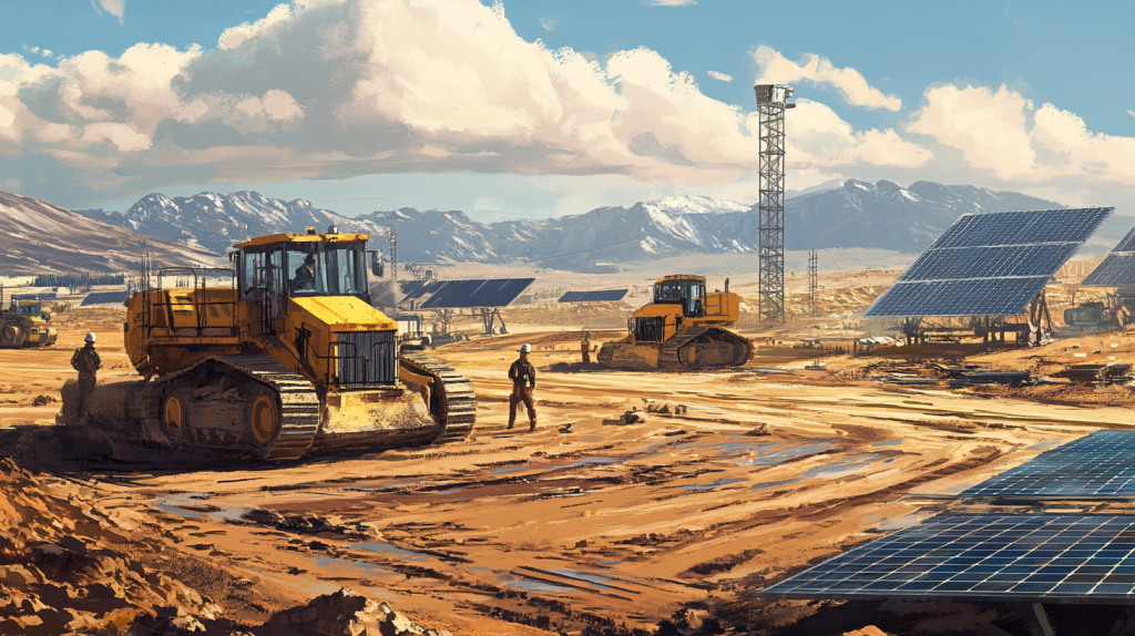
Construction site planning has traditionally relied on paper maps, surveys, and field inspections. While these tools remain valuable, they often lack the depth and flexibility needed for large-scale or complex projects. Geographic Information Systems (GIS) fill this gap by providing real-time, data-rich maps that give contractors, superintendents, and field teams a comprehensive understanding of the project environment.
GIS integrates multiple layers of information—such as topography, soil conditions, zoning boundaries, and existing infrastructure—into a single platform. This helps teams identify risks before they break ground, such as unstable soil, flood-prone areas, or conflicts with existing utilities. For superintendents managing massive jobsites, GIS offers a bird’s-eye view that supports smarter decision-making about equipment staging, crew assignments, and material deliveries.
The technology also enhances communication. Instead of relying on static drawings, teams can share interactive GIS maps that update in real time. Field crews, project managers, and stakeholders all access the same information, reducing errors caused by outdated or inconsistent documentation.
Top Benefits
- Provides real-time geographic data for site planning.
- Identifies risks such as soil instability or flood zones.
- Enhances collaboration through shared, interactive maps.
Best Practices for Using GIS in Site Planning
- Incorporate GIS data early in preconstruction.
- Update maps regularly to reflect changing site conditions.
- Train crews to use mobile GIS applications in the field.
By adding intelligence and context to site planning, GIS ensures projects start on a solid foundation and remain efficient throughout construction.
How Do Field Teams Use GIS for Utility Mapping?
Utility mapping is one of the most practical and impactful applications of GIS in construction. Field teams must know the exact location of underground and overhead utilities—water, sewer, electrical, gas, and telecommunications—to avoid costly and dangerous conflicts. Traditional utility maps are often incomplete or outdated, creating a major risk for contractors.
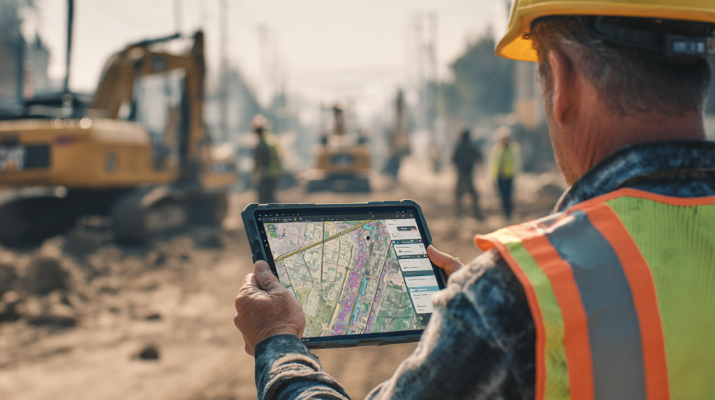
GIS solves this problem by consolidating utility data into interactive maps. These maps integrate information from public records, utility providers, and ground-penetrating radar surveys, giving crews a comprehensive and accurate view of subsurface and overhead systems. With GIS, workers in the field can access this information directly on tablets or smartphones, ensuring they dig or drill with confidence.
Utility mapping with GIS also improves coordination between trades. For example, if electrical crews know where water lines run, they can adjust trenching routes to avoid conflicts. Superintendents can schedule excavation, concrete pours, and equipment installations with far fewer interruptions.
Beyond safety and efficiency, GIS supports compliance. Many municipalities require accurate utility records to approve permits. GIS provides auditable, data-driven documentation that satisfies regulators and reduces liability for contractors.
Top Benefits
- Prevents costly and dangerous utility strikes.
- Improves coordination between multiple trades.
- Provides accurate, auditable records for regulators.
Best Practices for Utility Mapping with GIS
- Combine GIS data with utility provider records and surveys.
- Equip crews with mobile access to GIS maps onsite.
- Regularly update records as utilities are added or relocated.
For field teams, GIS transforms utility mapping from a guesswork process into a precise, data-driven task that improves both safety and productivity.
Related Articles:
Best Guide to Creating a Construction Site Utilization Plan with GIS Mapping, AI, and Logistics Tools

How Does GIS Improve Communication Between Office and Field Teams?
One of the most common challenges in construction is the disconnect between office planning and field execution. Plans may look perfect on paper but quickly run into conflicts once crews start work onsite. GIS helps close this gap by giving both office and field teams access to the same geographic information in real time.
In the office, project managers and engineers can use GIS to analyze site conditions, plan logistics, and coordinate utilities. These insights are then shared digitally with field crews through cloud-based platforms. Instead of flipping through paper maps or relying on verbal instructions, crews access interactive maps on mobile devices. Updates made in the office appear instantly onsite, reducing miscommunication and delays.
GIS also supports collaboration across multiple stakeholders. Owners, contractors, subcontractors, and inspectors can all view the same data, ensuring alignment. For example, if a change in excavation routes is needed due to soil instability, updates in the GIS platform immediately notify all relevant teams.
By streamlining communication, GIS eliminates one of the biggest sources of inefficiency in construction—poor information flow. It ensures that decisions made in the office are carried out accurately in the field, and that field insights are quickly fed back into the planning process.
Top Benefits
- Creates a shared platform for office and field teams.
- Reduces errors caused by outdated or inconsistent maps.
- Speeds up communication and decision-making.
Best Practices for Office-Field GIS Integration
- Use cloud-based GIS platforms with mobile access.
- Train teams to update maps as field conditions change.
- Encourage two-way communication between office planners and crews.
GIS strengthens the connection between planning and execution, ensuring field teams have the information they need, when they need it..

What Role Does GIS Play in Construction Safety and Risk Management?
Safety is always a top priority on construction sites, and GIS provides field teams with powerful tools to identify and mitigate risks before they become incidents. By combining geographic data with real-time field inputs, GIS helps contractors see potential hazards in context.
For example, GIS can highlight flood zones, unstable slopes, or hazardous soil conditions on interactive maps, ensuring crews know where risks exist before mobilizing equipment. It can also track utility conflicts, reducing the chances of accidental strikes during excavation. In regions like Louisiana, GIS can even integrate weather data, alerting crews to approaching storms and allowing managers to adjust schedules accordingly.
Risk management extends beyond physical hazards. GIS provides insights into traffic congestion around the jobsite, helping logistics teams plan safer delivery routes. It can also map emergency access points, ensuring crews and first responders have clear evacuation routes if needed.
By visualizing these risks spatially, GIS makes them easier for field teams to understand and respond to. Instead of reading a long safety report, workers see hazards directly on their mobile maps, which improves awareness and compliance.
Top Benefits
- Identifies hazards such as flood zones, unstable soils, or utilities.
- Improves response time to weather or environmental risks.
- Enhances situational awareness for crews and supervisors.
Best Practices for Safety and Risk Management with GIS
- Integrate GIS with weather monitoring systems.
- Use GIS maps to train crews on hazard awareness.
- Regularly update maps as conditions evolve onsite.
GIS transforms safety from a reactive process into a proactive strategy, reducing accidents and protecting both crews and communities.
How Does GIS Support Scheduling and Resource Allocation?
Construction schedules often look neat on paper but quickly become complex once materials, equipment, and crews hit the field. GIS helps align schedules with real-world conditions by showing where resources are located and how they interact with the jobsite.
For instance, GIS can map material laydown yards, equipment staging areas, and crew locations in real time. This allows superintendents to see whether resources are positioned efficiently or if bottlenecks are forming. By combining GIS data with project schedules, teams can ensure that deliveries, crane operations, and crew assignments are sequenced correctly.
Scheduling with GIS also improves accountability. When field teams log progress directly into GIS-enabled platforms, managers can compare actual work completed against the planned schedule. This visibility reduces surprises and allows corrective actions to be taken quickly.
Large projects benefit most from this integration. On mega campuses, GIS can track multiple work zones simultaneously, ensuring no area is overlooked and resources are balanced across the site.
Top Benefits
- Aligns schedules with real-time site conditions.
- Improves efficiency of material and equipment placement.
- Enhances accountability by comparing planned vs. actual progress.
Best Practices for Scheduling with GIS
- Integrate GIS data with project management software.
- Map resource locations daily to spot inefficiencies.
- Use GIS dashboards to monitor multiple work zones.
By pairing schedules with geographic context, GIS ensures that construction plans translate into effective, real-world execution.
StruxHub
Experience the power of StruxHub today and witness firsthand how it can revolutionize your construction operations.
What Challenges Do Field Teams Face When Using GIS?
While GIS provides major advantages, field teams can encounter challenges in adoption and execution. One common issue is data accuracy. If utility records or site surveys feeding into the GIS system are outdated, crews may be misled, increasing risk rather than reducing it. Contractors must validate GIS data regularly to ensure accuracy.
Training is another hurdle. While GIS is intuitive once adopted, many field workers are unfamiliar with the technology. Without proper training, crews may underutilize its features or revert to traditional methods. Ensuring user-friendly mobile interfaces and ongoing training sessions is key to widespread adoption.
Cost can also be a barrier. High-quality GIS platforms, drones, and sensors require upfront investment, which may be difficult for smaller contractors. However, the return on investment often justifies the expense by reducing rework, delays, and safety incidents.
Finally, integration with other systems can pose challenges. Contractors already rely on BIM, CAD, and project management software. If GIS platforms don’t connect smoothly with these tools, data silos can emerge. Choosing interoperable solutions is essential.
Top Benefits
- Identifies real-world barriers to GIS adoption.
- Encourages validation of data accuracy.
- Prepares teams for training and system integration.
Best Practices for Overcoming GIS Challenges
- Validate GIS data through regular surveys and inspections.
- Provide hands-on training for field crews.
- Select platforms that integrate with BIM and project management tools.
By addressing these challenges proactively, contractors can maximize the benefits of GIS while minimizing potential pitfalls.
How StruxHub Enhances GIS Use for Field Teams
While GIS provides powerful data, its effectiveness depends on how well it integrates with daily workflows. StruxHub helps bridge this gap by connecting GIS data directly to field operations.
For superintendents, StruxHub allows GIS maps to be linked to project schedules, delivery logs, and inspection tasks. Field teams can access these maps on mobile devices, ensuring they always work from the most up-to-date information. Crews can also log progress, photos, and notes directly into StruxHub, which syncs with GIS layers to provide real-time visibility.
StruxHub enhances utility mapping by centralizing communication. If a new utility is discovered onsite, crews can update the GIS map within StruxHub, immediately notifying other trades and preventing conflicts. The platform also supports safety by linking GIS hazard maps to daily checklists, ensuring crews acknowledge risks before starting work.
Top Benefits
- Integrates GIS directly with field operations and schedules.
- Improves communication when utilities or hazards change onsite.
- Provides mobile access for crews in real time.
Best Practices for Using StruxHub with GIS
- Connect GIS maps to delivery and inspection workflows.
- Train crews to log updates directly into the system.
- Use dashboards for transparent communication across trades.
By embedding GIS into daily workflows, StruxHub ensures the technology is not just a planning tool but a practical asset for superintendents and field crews.

StruxHub: Revolutionizing Project Management in Large Commercial Construction
FAQ
How does GIS improve accuracy in construction site planning?
GIS improves accuracy by consolidating multiple data sources—such as surveys, utility maps, soil studies, and drone imagery—into one digital platform. Traditionally, site planning relied on paper maps and static surveys, which could quickly become outdated. With GIS, field teams can access real-time information that reflects current conditions.
For example, GIS can identify soil stability issues, flood zones, or elevation changes that may affect foundation design. It can also overlay zoning boundaries and easements, helping contractors avoid compliance issues. By layering these datasets, planners gain a holistic view of the site that reduces uncertainty.
Accuracy is further enhanced when GIS integrates with GPS-enabled equipment. Excavators, graders, and survey tools can feed live data into GIS maps, confirming that earthwork aligns with design plans. Any discrepancies are flagged instantly, allowing for immediate corrections.
In utility planning, GIS eliminates guesswork by consolidating records from providers, ground-penetrating radar scans, and as-built surveys. This reduces the risk of hitting unmarked lines during excavation, one of the costliest and most dangerous errors in construction.
Ultimately, GIS ensures that decisions are based on accurate, real-world data rather than assumptions. This leads to fewer delays, fewer change orders, and better resource allocation throughout the project lifecycle.
How do field teams access and use GIS data onsite?
Field teams typically access GIS data through mobile devices such as tablets or smartphones connected to cloud-based platforms. Instead of carrying paper maps or relying on verbal instructions, crews can open interactive GIS maps that display utilities, hazards, and site layouts in real time.
This mobile access ensures that crews are always working with the latest information. If the office team updates a map—for example, rerouting an excavation path due to soil instability—the changes appear immediately for field workers. Conversely, if field crews discover an undocumented utility line, they can log it directly into the GIS platform, updating the map for everyone else.
GPS-enabled tools also allow workers to pinpoint their exact location relative to mapped utilities or hazards. This level of precision helps prevent errors such as digging in the wrong area or misaligning equipment.
Superintendents use GIS dashboards to assign tasks, monitor crew activity, and track progress. Photos, notes, and inspection results can all be linked to GIS layers, creating a detailed record of site activity. This improves accountability and provides auditable documentation for owners and regulators.
In short, mobile GIS access transforms data into action. It bridges the gap between office planning and field execution, ensuring crews work more safely, efficiently, and accurately.
What risks does GIS help prevent in construction?
GIS helps prevent several high-risk issues that can derail construction projects. One of the most significant is utility strikes. By consolidating accurate maps of underground and overhead utilities, GIS reduces the chances of hitting water, gas, or electrical lines—incidents that can cause injuries, project delays, and costly repairs.
Another risk is environmental damage. GIS highlights flood zones, wetlands, and protected habitats, ensuring construction avoids or mitigates sensitive areas. This not only protects ecosystems but also prevents legal penalties or permit violations.
Logistical risks are also minimized. GIS maps traffic patterns, delivery routes, and staging areas, preventing congestion and reducing the risk of accidents involving trucks and heavy equipment. By visualizing these routes, logistics managers can plan safer, more efficient workflows.
Weather-related risks can also be managed with GIS. By integrating real-time weather data, GIS platforms can alert crews to storms, high winds, or heatwaves, allowing managers to adjust schedules and protect workers.
In essence, GIS reduces the unknowns that often lead to costly mistakes or unsafe conditions. By providing a clear picture of site conditions, utilities, and risks, it helps contractors anticipate challenges and avoid them before they become incidents.
How does GIS compare to traditional surveying in construction projects?
Traditional surveying provides precise measurements of site features such as boundaries, elevations, and grades. While surveys remain essential, they are often static snapshots that must be updated manually as conditions change. GIS, on the other hand, builds on survey data by creating a dynamic, layered platform that integrates multiple datasets and updates in real time.
For example, a survey might show the exact elevation of a site, but GIS can overlay that elevation data with soil types, flood risk zones, and existing utilities. This broader context helps teams make more informed decisions. Surveys excel at precision, while GIS excels at integrating precision with context.
Another key difference is accessibility. Survey data often remains in technical drawings that require specialized training to interpret. GIS makes the same information accessible through user-friendly maps that crews can use on mobile devices. This democratizes information across the entire project team.
Finally, GIS supports ongoing monitoring. Drone imagery, IoT sensors, and GPS-enabled equipment can feed data back into the system, ensuring maps remain current throughout construction. Surveys rarely provide this level of continuous update.
In short, GIS doesn’t replace surveying—it enhances it. Together, they provide both the precision and the context needed to manage modern construction projects effectively.
How does StruxHub integrate GIS for field team efficiency?
StruxHub enhances GIS by embedding it directly into daily construction workflows. While GIS provides valuable maps and data, field teams need an easy way to connect that information with tasks, schedules, and reports. StruxHub serves as the bridge, ensuring GIS is not just a planning tool but an actionable resource onsite.
With StruxHub, superintendents can link GIS maps to specific jobsite activities. For example, a utility map can be tied to excavation tasks, ensuring crews review underground hazards before digging. Hazard zones identified in GIS can be integrated into safety checklists, requiring acknowledgment from crews each morning.
Field teams access GIS data directly through StruxHub’s mobile app, ensuring they always work with the latest maps. When crews discover new utilities or changing conditions, they can log updates directly into the system, instantly notifying other teams and preventing conflicts.
For project leaders, StruxHub dashboards consolidate GIS data with schedules, deliveries, and inspections. This provides a real-time view of progress, risks, and logistics, improving coordination across the site.
In practice, StruxHub transforms GIS from a standalone platform into part of a seamless field management system. It ensures that geographic data directly supports safe, efficient, and accountable construction operations.

StruxHub
Discover how StruxHub can revolutionize your construction management. Contact us today!
Pillar Articles Links:
Best Guide to Construction Logistics Plans (CLPs): What Owners Want to See Before Work Starts
Best Construction Scheduling Software for General Contractors and Superintendents